var map = new GMap2(document.getElementById("map"));
map.addControl(new GSmallMapControl());
map.addControl(new GMapTypeControl());
map.setCenter(new GLatLng(50.7424807, 10.5104448), 15);
/* L‰dt die Daten in data.xml herunter und l‰dt sie auf die Karte. Das erwartete Format lautet:
*/
var point1 = new GPoint(10.5080907772216796, 50.743567149598945);/**/
var icon2 = new GIcon();
icon2.image = "../images/schild.png";
icon2.shadow = "../images/schild_schatten.png";
icon2.iconSize = new GSize(100, 60);
icon2.shadowSize = new GSize(160, 60);
icon2.iconAnchor = new GPoint(6, 20);
icon2.infoWindowAnchor = new GPoint(0, 0);
var struth = new GMarker(point1, icon2);
GEvent.addListener(struth, "click", function() {struth.openInfoWindowHtml(html1)});
map.addOverlay(struth);
var html1 = "Ferienhaus Familie Danz
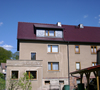 Kirchweg 22
98593 Floh-Seligenthal
Route erstellen
"
GDownloadUrl("geso.xml", function(data, responseCode) {
var xml = GXml.parse(data);
var markers = xml.documentElement.getElementsByTagName("marker");
for (var i = 0; i < markers.length; i++) {
var point = new GLatLng(parseFloat(markers[i].getAttribute("lat")),
parseFloat(markers[i].getAttribute("lng")));
map.addOverlay(new GMarker(point));
}
});